HIGHLIGHTS
- Head
up to the northern part of Baffin Island, the entrance to the Northwest
Passage
- Experience
the beauty of fjords and crystal clear glaciers
- Visit
small towns and villages to encounter a fascinating mix of local and
Danish culture in Greenland, or local and Canadian culture on Baffin
Island
- Look
for polar bears, seals, narwhals and walrus from the ship or during
Zodiac cruises
- Throughout
the voyage, learn about the history, geology, wildlife and botany of
this spectacular area from lecture presentations offered by your
knowledgeable onboard Expedition Team
DATES / RATES
Rates are listed per person in USD. Promotional offers are not reflected in the rates below.
|
| Start Date | End Date | Vista Suite | Veranda Suite | Deluxe Veranda Suite | Medallion Suite | Silver Suite | Royal Suite | Grand Suite | Owner's Suite |
|---|
Rates are listed per person in USD. Promotional offers are not reflected in the rates below.
|
| Start Date | End Date | (Starting from)
Vista Suite | (Mid-range)
Silver Suite | (High-end)
Owner's Suite |
|---|
ITINERARY
Days
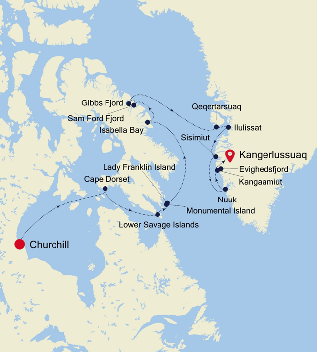
1-2: Churchill (Manitoba), Canada
Day
3: At Sea
Days at sea
are the perfect opportunity to relax, unwind and catch up with what
you’ve been meaning to do. So whether that is going to the
gym, visiting the spa, whale watching, catching up on your reading or
simply topping up your tan, these blue sea days are the perfect balance
to busy days spent exploring shore side.
Day
4: Cape Dorset (Dorset Island), Canada
Cape Dorset
is a small Inuit hamlet located on Dorset Island, off the southern
shore of Baffin Island. The traditional name for Cape Dorset is
Kinngait (meaning "high mountain"), describing the
‘Cape’, which is actually a 800 foot mountain. This
is a nature-lovers paradise with breath-taking landscapes and an
amazing abundance of arctic wildlife, such as migratory caribou,
seabirds, whales, seals and walruses. Ancient native Thule (Dorset
Culture) peoples lived in this area for three thousand years, and it is
here where the first archaeological remains were found. Captain Luke
Foxe, during his attempt to find the Northwest Passage in 1631, was the
first European to land here. He named the Cape in honour of his sponsor
Edward Sackville, the Earl of Dorset. In 1913, the Hudson's Bay Company
started a trading post, exchanging furs and skins for supplies like
tobacco, ammunition, flour, gas, tea and sugar. Read more
Day
5: Lower Savage Islands, Canada
The Lower
Savage Islands are a small group of islands off of the southeastern tip
of Baffin Island, and a common location for polar bears to be found
during the summer months. With plenty of land to roam while giving each
other a wide berth, plus opportunities to feed, it seems perhaps bears
can be found here as the ice vanishes with the summer
season’s warming temperatures.
Day
6: Monumental Island, Canada
Monumental
Island in Davis Strait was named by Arctic explorer Charles Francis
Hall as a tribute to the memory of Sir John Franklin who died in his
quest to find the Northwest Passage. The island is offshore of Baffin
Island in the Canadian Arctic Archipelago of the territory of Nunavut.
Around the shoreline scores of Black Guillemots dive and fish for
little Arctic cods and capelins. Successful birds fly off with a minnow
grasped tightly in their beaks. On a far larger scale, it is possible
to find groups of walruses with their impressive tusks along the shores
of the island. However, the coup de grâce is to spot a polar
bear’s white silhouette against the dark background of the
bedrock on Monumental Island.
Lady
Franklin Island, Canada
Named in
honour of Sir John Franklin’s widow, the lonely and
uninhabited Lady Franklin Island lies off of Baffin Island’s
Hall Peninsula at the entrance to Cumberland Sound. The island is named
for the wife of Sir John Franklin, the Arctic explorer who died trying
to discover the Northwest Passage. The geology of the island is
striking with vertical cliffs of Archean rocks, likely to be some of
the oldest stone in Canada. The waters around Lady Franklin Island
offer an abundance seabirds, ducks, seals, and walrus. With a bit of
luck it is possible to see Atlantic Puffins here and perhaps even a
rare Sabine’s Gull.
Day
7: At Sea
Day
8: Isabella Bay (Nunavut), Canada
The
shoreline and islands of Isabella Bay, as well as the adjacent ocean
out to 12 nautical miles from shore, was folded into Canada’s
Ninginganiq National Wildlife Area in 2010. Located on the northeast
coast of Baffin Island, Nunavut, Isabella Bay provides important marine
habitat for bowhead whales, other marine mammals, and a plethora of
seabirds. As a result of the formation of the Ninginganiq National
Wildlife Area the eastern bowhead population may now be over 10,000
individuals.
Day
9: Sam Ford Fjord (Nunavut), Canada
The starkly
beautiful Sam Ford Fjord area of Baffin Island has one of the most
impressive concentrations of vertical rock walls to be found anywhere
in the world. It is a 110-kilometer (68-mile) waterway lined with sheer
cliffs that have attracted some of the world’s best (and most
extreme) rock climbers to the region. The steep stone walls were formed
by ancient glaciers that carved the landscape through the ages.
However, the feature that makes the shoreline truly special is the way
that many of these walls rise straight up from the dark waters of the
deep fjord. Swimming these waters are marine mammals including narwhals
and seals that once attracted Inuit hunters to this coast.
Day
10: Gibbs Fjord (Nuvanut), Canada
There are
few places on earth where the simple grandeur of the landscape can
dwarf a ship with giant peaks, steep cliffs, and glacial rivers of ice.
In Gibbs Fjord it is possible to see only towering cliffs and the
seemingly impenetrable fortress of 4,000-foot walls and buttresses that
make up Sillem Island, eventually dividing the dark, deep waters of
Gibbs and Clark Fjords. The geological formations here make for
excellent photo opportunities and it is astounding to realize that very
little of this spectacular terrain has ever been explored.
Day
11: At Sea
Day
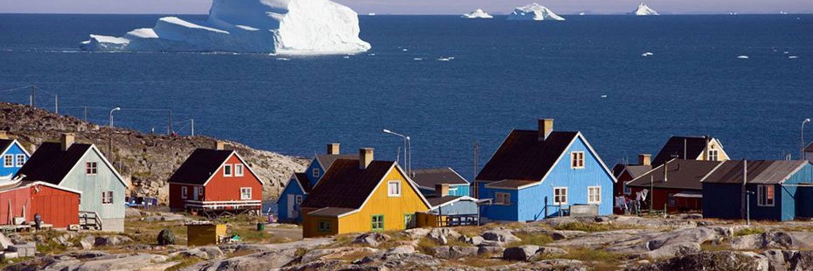
12: Qeqertarsuaq, Greenland
During the
morning Silver Cloud will ply the Disko Bay en route to our destination
along Disko Island’s east coast. Our exploration of the Disko
Bay area will head to an area north of the village of Qeqertarsuaq,
which is named after Disko Island’s local name
–meaning “large island”. With more than
3,300 sq. miles Disko Island is Greenland’s second-largest
island.
Day
13: Ilulissat, Greenland
Known as
the birthplace of icebergs, the Ilulissat Icefjord produces nearly 20
million tons of ice each day. In fact, the word Ilulissat means
“icebergs” in the Kalaallisut language. The town of
Ilulissat is known for its long periods of calm and settled weather,
but the climate tends to be cold due to its proximity to the fjord.
Approximately 4,500 people live in Ilulissat, the third-largest town in
Greenland after Nuuk and Sisimiut. Some people here estimate that there
are nearly as many sled dogs as human beings living in the town that
also boasts a local history museum located in the former home of
Greenlandic folk hero and famed polar explorer Knud Rasmussen.
Day
14: Sisimiut, Greenland
Located
just north of the Arctic Circle, Sisimiut is the northernmost town in
Greenland where the port remains free of ice in the winter. Yet it is
also the southernmost town where there is enough snow and ice to drive
a dogsled in winter and spring. In Sisimiut, travelling by sled has
been the primary means of winter transportation for centuries. In fact,
the area has been inhabited for approximately 4,500 years. Modern
Sisimiut is the largest business center in the north of Greenland, and
is one of the fastest growing Greenlandic cities. Commercial fishing is
the lead economy in the town‘s thriving industrial base.
Day
15: Nuuk (Godthab), Greenland
Nuuk,
meaning “the cape”, was Greenland’s first
town (1728). Started as a fort and later mission and trading post some
240 kilometers south of the Arctic Circle, it is the current capital.
Almost 30% of Greenland’s population lives in the town. Not
only does Nuuk have great natural beauty in its vicinity, but there are
Inuit ruins, Hans Egede’s home, the parliament, and the
Church of our Saviour as well. The Greenlandic National Museum has an
outstanding collection of Greenlandic traditional dresses, as well as
the famous Qilakitsoq mummies. The Katuaq Cultural Center’s
building was inspired by the undulating Northern Lights and can house
10% of Nuuk’s inhabitants.
Day
16: Evighedsfjord, Greenland
Within
roughly an hour of steaming south from Kangerlussuaq Fjord is
Evighedsfjord Fjord. The fjords in this area can reach close to a
kilometer (over half a mile) of depth and are lined with tidewater
glaciers from the Maniitsoq ice sheet located high up in the interior
of Greenland. Some of the cliffs along the fjords of this region can
exceed 2,000 metres (6,600 ft.) in height.
Kangaamiut
(Qeqqata), Greenland
Only 350
people live in the small Greenlandic community of Kangaamiut. Located
on the south coast of Timerdlit Island and facing the Davis Strait,
Kangaamiut is situated between the mouths of two long fjords: the
Kangerlussuatsiaq Fjord (or Evighedsfjorden in Danish) to its south and
to its north Kangaamiut Kangerluarsuat Fjord. Founded in 1755, it was
called “Sugarloaf” (Sukkertoppen) because of the
appearance of three nearby hills.
Day
17: Kangerlussuaq, Greenland
Arrive 6:00
AM
Kangerlussuaq
is a settlement in western Greenland in the Qeqqata municipality
located at the head of the fjord of the same name (Danish:
Søndre Strømfjord). It is Greenland's main air
transport hub and the site of Greenland's largest commercial airport.
The airport dates from American settlement during and after World War
II, when the site was known as Bluie West-8 and Sondrestrom Air Base.
The Kangerlussuaq area is also home to Greenland's most diverse
terrestrial fauna, including muskoxen, caribou, and gyrfalcons. The
settlement's economy and population of 512 is almost entirely reliant
on the airport and tourist industry.
 (Click image to view Ship details)
WHAT'S INCLUDED
- Guided
Zodiac, land and sea tours, and shoreside activities led by the
Expeditions Team
- Parka
- Enrichment
lectures by a highly qualified Expeditions Team
- Spacious
suites
- Butler
service in every suite
- Unlimited
Free Wifi
- Personalised
service – nearly one crew member for every guest
- Choice
of restaurants, diverse cuisine, open-seating dining
- Beverages
in-suite and throughout the ship, including champagne, select wines and
spirits
- In-suite
dining and room service
- Onboard
entertainment
- Onboard
gratuities